barnstorm2
Platinum Member
- Joined
- Nov 1, 2003
- Messages
- 14,573
- Location
- Cincinnati, Ohio
- Aircraft
- 2-place Air Command CLT SxS (project), & Twinstarr Autogyro
- Total Flight Time
- 750+hrs and climbing
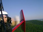
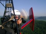
Connie and I both agree our favorite Cross Country gyroplane trip was this mornings flight to Portsmouth for breakfast.
(ok I am posting this at 1:30am so technically it is yesterday's flight...)
Connie loves to fly to breakfast and since there were no known scheduled EAA breakfast fly-ins and we had already been to Lumberton (see other thread) Mark Webb a flying buddie with a great KitFox fixed wing suggested we fly to Portsmouth Ohio. He told us there was a great old vintage diner right on the airport.
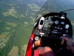
We got to the airport at 7am and were in the air by 7:30.
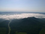
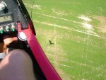
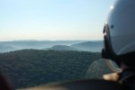
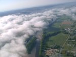
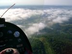
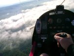
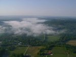
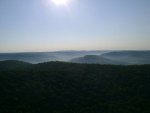
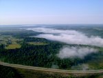
As soon as we got into the pattern we could see patchy ground fog in all directions.
For those not familiar with the restrictions for Private Pilot VFR, I have to be able to keep visual contact with at least a portion of the ground at all times.
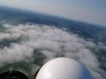
Thankfully, the ground fog (low clouds) were quite wispy and even directly above them we could still make out ground features.
The air was perfectly still and about 80deg F. air temp.
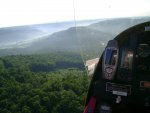
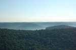
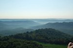
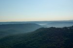
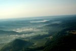
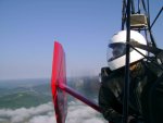
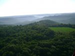
As the sun cast shadows over the trees and the low clouds rose from the ground the scene turned into what I can only describe as a dreamscape.
The view was the most inspiring and awesome I have ever seen in all of my flying days.
The photos I will be posting in this tread are hardly even mere shadows of the scenic beauty we saw. The cameras were nearly useless for capturing the landscape.
I would urge you to click on many of the photos as even in full size the photos only hint at what it was like.
I have never flown to Portsmouth Ohio before. It is a little over an hours flight time away (at about 85mph) and almost due East of my airport in Cincinnati. In fact I had never flown farther (directly) east then the East Fork Region of Ohio.
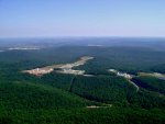
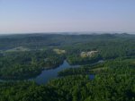
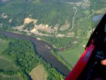
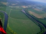
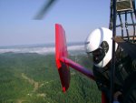
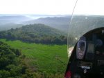
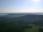
The terrain was breathtaking in more than one way.
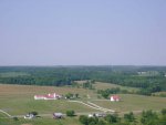
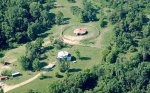
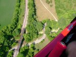
The first third of the trip was mostly small farmland. We even noted several small grass strip runways that were not on the sectional.
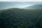
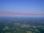
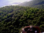
However, the last two thirds of the trip quickly turned into terrain that was hilly, wooded and then 'mountainous'* and wooded!
At first most of foot hills had some form of a farm or non-wooded section on one side or the other but as they grew deeper and larger and higher they started to become completely wooded!
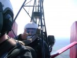
There were several times when I flew over terrain that I would not have been able to land on. As this is very unwise I started making my way toward the road that ran between the hillsides so that I would at least have some option in an emergency even if it was not a great one. (I started thinking about how long it had been since I changed the oil in the Lycoming....etc...)
At this point I was starting to experience what is known as the 'pucker' effect.
I changed course off of my GPS heading for Portsmouth and headed for the highway I had seen parallel to me recently and my GPS told me would be over the next hill-crest.
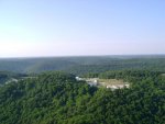
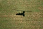
I came up over the hill climbing and what we saw on top of the hill made both Connie and I exclaim 'Wow' simultaneously.
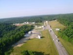
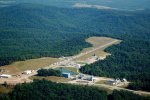
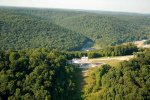
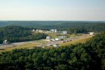
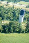
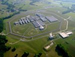
It was a runway with heli-pads all around it. The runway was X-ed off for closed and huge strange buildings and giant equipment was all over the hillcrest.
There were white metal cylinders larger then office buildings and all kinds of equipment and bizarre buildings.
I felt like I had just stumbled into a Sci-Fi novel!
I radio'ed Mark and he said it was a private airfield owned by General Electric.
I remembered the private airport on the sectional during flight planning but did not expect to find anything more than a farmer's grass strip!!
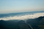
As we approached Portsmouth and the GPS started ticking down the miles my heart sank. The way ahead was covered for a few miles with a blanket of low clouds.
I checked my fuel and I had about 45 minutes left so I could not go straight back, I would have to find an alternate airport (the GE runway was clear of fog but that would be a LAST resort!!).
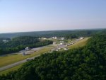
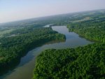
But the worry was unfounded. It turns out there is a river valley (a tributary of the Ohio) that runs through a deep wide valley before Portsmouth. The airport was on the other side of this valley and quite clear of all clouds and fog. whew!
We set down in calm smooth air that had not even woken the windsock up yet this morning.
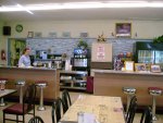
The diner was GREAT. The diner was actually part of the FBO building. I don't know how old it was but it had a 50's style and lots of old photos and newspapers from the 1920's through the 60's.
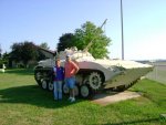
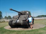
There was a "Tank" (APC) out front and I asked Connie and Mark to let me take a picture of them next to it.
Connie sighed "Not more Tanks!?!"
Mark looked at her then me and I explained last weekend we took a bike trip to a 1800's mill turned B&B in Kentucky and I "made" Connie go to the General Patton Museum at Fort Knox.
Breakfast for two was $10 (Gas was $51.00)
As we left it was obvious the sun was getting it's work done and the wind had woken up the windsock and the thermals.
I climbed to 2700 feet (AGL) as to avoid pucker factor for the part of the trip that was heavily wooded. As we passed this and got back to rolling hills with spotted farmland I decended back down to the more 'gyro-like' 500ft AGL.
We passed a farm that looked "perfect". It looked like it just came off of the label in the supermarket. I pointed this out to Connie on the way to Portsmouth. She noted on the way back that there were no animals to be seen and no crops to speak of around the farm. A creepy "twilight zone" feeling crept over me and I upped the cruise speed...
Well that was the trip. Not much to tell on paper but being there make it our best so far.
I have one more thing to put in this thread...
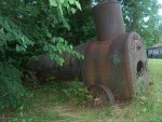
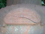
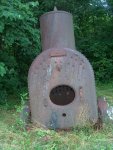
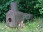
While staying at the 1800's mill B&B in KY I found in the woods an old steam boiler on wheels. At first I thought I had come across some kind of old steam powered train engine or tractor but I could see no way that the wheels were powered.
I will post the photos I have of it here in hopes someone here can tell me what it is or help lead me to where I can research it.
It is now 2:20am so I am only going to post the photos I took tonight. Tomorrow when I get up I will add Connie's photos from the trip to this thread.
Thanks for viewing!!
*(my apologies to those of you that fly though REAL mountains. These ranges of hills are the foothills of the smokey mountains. While far from REAL mountain flying they still pose great risk and provide great beauty as well. From an Ohio flatlanders perspective, we get away with calling these hills mountains as it is the best we have...)
All photos are high-res. Please click on a photo to see it full-size. Hightly recommend for the cloud shots.
2700feet.jpg (114.9 KB)
2700FootRiver.jpg (135.4 KB)
2700WindingRiver.jpg (101.5 KB)
AboveTheClouds.jpg (88.2 KB)
Bridges.jpg (116.2 KB)
CealingAT3000.jpg (106.3 KB)
CloudsApprochingPsmith.jpg (112.1 KB)
CloudsToPsmith.jpg (105.9 KB)
.
(ok I am posting this at 1:30am so technically it is yesterday's flight...)
Connie loves to fly to breakfast and since there were no known scheduled EAA breakfast fly-ins and we had already been to Lumberton (see other thread) Mark Webb a flying buddie with a great KitFox fixed wing suggested we fly to Portsmouth Ohio. He told us there was a great old vintage diner right on the airport.
We got to the airport at 7am and were in the air by 7:30.
As soon as we got into the pattern we could see patchy ground fog in all directions.
For those not familiar with the restrictions for Private Pilot VFR, I have to be able to keep visual contact with at least a portion of the ground at all times.
Thankfully, the ground fog (low clouds) were quite wispy and even directly above them we could still make out ground features.
The air was perfectly still and about 80deg F. air temp.
As the sun cast shadows over the trees and the low clouds rose from the ground the scene turned into what I can only describe as a dreamscape.
The view was the most inspiring and awesome I have ever seen in all of my flying days.
The photos I will be posting in this tread are hardly even mere shadows of the scenic beauty we saw. The cameras were nearly useless for capturing the landscape.
I would urge you to click on many of the photos as even in full size the photos only hint at what it was like.
I have never flown to Portsmouth Ohio before. It is a little over an hours flight time away (at about 85mph) and almost due East of my airport in Cincinnati. In fact I had never flown farther (directly) east then the East Fork Region of Ohio.
The terrain was breathtaking in more than one way.
The first third of the trip was mostly small farmland. We even noted several small grass strip runways that were not on the sectional.
However, the last two thirds of the trip quickly turned into terrain that was hilly, wooded and then 'mountainous'* and wooded!
At first most of foot hills had some form of a farm or non-wooded section on one side or the other but as they grew deeper and larger and higher they started to become completely wooded!
There were several times when I flew over terrain that I would not have been able to land on. As this is very unwise I started making my way toward the road that ran between the hillsides so that I would at least have some option in an emergency even if it was not a great one. (I started thinking about how long it had been since I changed the oil in the Lycoming....etc...)
At this point I was starting to experience what is known as the 'pucker' effect.
I changed course off of my GPS heading for Portsmouth and headed for the highway I had seen parallel to me recently and my GPS told me would be over the next hill-crest.
I came up over the hill climbing and what we saw on top of the hill made both Connie and I exclaim 'Wow' simultaneously.
It was a runway with heli-pads all around it. The runway was X-ed off for closed and huge strange buildings and giant equipment was all over the hillcrest.
There were white metal cylinders larger then office buildings and all kinds of equipment and bizarre buildings.
I felt like I had just stumbled into a Sci-Fi novel!
I radio'ed Mark and he said it was a private airfield owned by General Electric.
I remembered the private airport on the sectional during flight planning but did not expect to find anything more than a farmer's grass strip!!
As we approached Portsmouth and the GPS started ticking down the miles my heart sank. The way ahead was covered for a few miles with a blanket of low clouds.
I checked my fuel and I had about 45 minutes left so I could not go straight back, I would have to find an alternate airport (the GE runway was clear of fog but that would be a LAST resort!!).
But the worry was unfounded. It turns out there is a river valley (a tributary of the Ohio) that runs through a deep wide valley before Portsmouth. The airport was on the other side of this valley and quite clear of all clouds and fog. whew!
We set down in calm smooth air that had not even woken the windsock up yet this morning.
The diner was GREAT. The diner was actually part of the FBO building. I don't know how old it was but it had a 50's style and lots of old photos and newspapers from the 1920's through the 60's.
There was a "Tank" (APC) out front and I asked Connie and Mark to let me take a picture of them next to it.
Connie sighed "Not more Tanks!?!"
Mark looked at her then me and I explained last weekend we took a bike trip to a 1800's mill turned B&B in Kentucky and I "made" Connie go to the General Patton Museum at Fort Knox.
Breakfast for two was $10 (Gas was $51.00)
As we left it was obvious the sun was getting it's work done and the wind had woken up the windsock and the thermals.
I climbed to 2700 feet (AGL) as to avoid pucker factor for the part of the trip that was heavily wooded. As we passed this and got back to rolling hills with spotted farmland I decended back down to the more 'gyro-like' 500ft AGL.
We passed a farm that looked "perfect". It looked like it just came off of the label in the supermarket. I pointed this out to Connie on the way to Portsmouth. She noted on the way back that there were no animals to be seen and no crops to speak of around the farm. A creepy "twilight zone" feeling crept over me and I upped the cruise speed...
Well that was the trip. Not much to tell on paper but being there make it our best so far.
I have one more thing to put in this thread...
While staying at the 1800's mill B&B in KY I found in the woods an old steam boiler on wheels. At first I thought I had come across some kind of old steam powered train engine or tractor but I could see no way that the wheels were powered.
I will post the photos I have of it here in hopes someone here can tell me what it is or help lead me to where I can research it.
It is now 2:20am so I am only going to post the photos I took tonight. Tomorrow when I get up I will add Connie's photos from the trip to this thread.
Thanks for viewing!!
*(my apologies to those of you that fly though REAL mountains. These ranges of hills are the foothills of the smokey mountains. While far from REAL mountain flying they still pose great risk and provide great beauty as well. From an Ohio flatlanders perspective, we get away with calling these hills mountains as it is the best we have...)
All photos are high-res. Please click on a photo to see it full-size. Hightly recommend for the cloud shots.
2700feet.jpg (114.9 KB)
2700FootRiver.jpg (135.4 KB)
2700WindingRiver.jpg (101.5 KB)
AboveTheClouds.jpg (88.2 KB)
Bridges.jpg (116.2 KB)
CealingAT3000.jpg (106.3 KB)
CloudsApprochingPsmith.jpg (112.1 KB)
CloudsToPsmith.jpg (105.9 KB)
.
Attachments
-
 2700FootRiver.jpg104.3 KB · Views: 0
 -
 2700feet.jpg86.3 KB · Views: 0
 -
 AboveTheClouds.jpg47.9 KB · Views: 0
 -
 2700WindingRiver.jpg78.1 KB · Views: 0
 -
 Bridges.jpg101.9 KB · Views: 0
 -
 CealingAT3000.jpg70.3 KB · Views: 0
 -
 CloudsApprochingPsmith.jpg55.7 KB · Views: 0
 -
 CloudsToPsmith.jpg64.2 KB · Views: 0

 arty:
arty: