Putting together an accident chain.

Vance

Gyroplane CFI
Staff member
Joined
Oct 30, 2003
Messages
18,378
Location
Santa Maria, California
Aircraft
Givens Predator
Total Flight Time
2600+ in rotorcraft
I love how passion for gyroplanes transcends borders, language and culture.

Gerhard was going to be in California briefly visiting from Switzerland and wanted to stop by because of reading my posts on Facebook. He is a licensed gyroplane pilot in Germany and has had a business relationship with AutoGyro GMBH; the largest producer of gyroplanes in the world.

I could tell quickly on the phone that Gerhard was someone I would like to spend time with and he was gracious when I explained I could not give him flight instruction without going through the Transportation Security Administration because he was not a citizen of the USA. They suggest the process takes six weeks so there was simply not enough time. Gerhard would like to get an FAA gyroplane pilot certificate and I explained the avenues available to him.

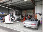
Gerhard was punctual and I let him in the gate when I received his call. The hangar was a little full with the addition of Robert’s aircraft and we had an interesting, animated conversation till we began to see patches of blue.

Gerhard’s enthusiasm for flying gyroplanes was infectious and his imagination wondrous. He expressed some ideas about selling gyroplanes that seemed clever and workable to me.

The local weather was very much “June Gloom” making a flight up the beach impractical. Gerhard didn’t want to miss the opportunity to fly a gyroplane in California so we decided to fly to San Luis Obispo direct (SBP) weather permitting.

I checked the weather and Santa Maria (SMX) had nine miles visibility with the ceiling at 1,200 feet and SBP had seven miles visibility and the ceiling was 1,400 overcast. Visual Flight Rules minimums are three miles and 1,000 feet so we were legal but it was probably not smart with my judgement being clouded by the narrow window of opportunity and Gerhard’s strong desire to fly.

San Luis Obispo is twenty two nautical miles North West of SMX if you fly direct and I fly there often so I am familiar with the geographical features as seen from the air although I seldom fly direct to anywhere.

I called the SBP air traffic control 13 miles to the South East at 1,200 feet with information Romeo; inbound to land. I was to fly direct to runway two niner remaining south of the centerline and report four miles.

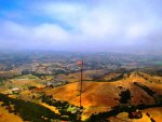
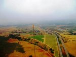
At seven miles out I was made aware of some faster traffic at my four o’clock high that would pass off to my right. My panel powered GPS went blank (blew a fuse and the batteries went dead) and I realized I did not have the airport in sight. The Edna Valley looks different shrouded in mist and I let the tower know I was not sure of my position and did not have the airport in sight. I looked at the chart but it was not much help.

The faster plane passed high off to my right and I reported him in sight.

I could see I was putting together the links of a classic accident chain and preparing to turn around just as I identified the airport. I was still about six miles out and reported; “airport in sight”. The tower shot back; “Gyroplane 142 Mike Golf; Runway Two Niner Clear to Land.”

We had a lovely lunch and the flight back was uneventful.

For those unfamiliar; the mistakes I made were:
  1. Anxious to fly because of Gerhard’s limited window of opportunity.
  2. Overconfidence because of my familiarity with the route, local weather and the aircraft.
  3. Marginal weather with near minimum VFR conditions at both the departure airport and the destination airport.
  4. Equipment failure; The GPS is not my primary navigation. It is useful when describing my location to ATC.
  5. I was not able to use the chart effectively because of our low altitude and the mist.
Fortunately the accident chain was broken by my familiarity with the route and good luck.

Plan B would have been turn around and follow highway 101 back to SMX.

Plan C would have been to fly to Taft to get away from the coastal fog and we had enough fuel on board for plan C.

I share this experience in the hopes it will allow others to recognize and break the accident chain before it becomes an NTSB report. For most accidents the accident chain is begins before flight.

Gerhard seemed undaunted by my mistakes and I very much enjoyed his visit and our flight together. I look forward to our ongoing friendship.
 

Attachments

  • photo130252.jpg
    photo130252.jpg
    91.8 KB · Views: 2
  • photo130253.jpg
    photo130253.jpg
    97.6 KB · Views: 2
  • photo130254.jpg
    photo130254.jpg
    39.4 KB · Views: 2
  • photo130255.jpg
    photo130255.jpg
    100.2 KB · Views: 2
  • photo130256.jpg
    photo130256.jpg
    86 KB · Views: 2
  • photo130257.jpg
    photo130257.jpg
    71.8 KB · Views: 2
Good article about how things can get out of control,I was told that the accident chain starts when you

get out of bed in the morning.What you went through is a good reminder of that.
 
Thanks for sharing Vance. I have found a Smart phone with Foreflight or WingXPro which is free is better than a paper chart for back up in an open cockpit environment. I keep all three when flying longer flights.
 
Last edited:
Good recovery Vance. I think you are too hard on yourself. IMHO you had a couple of "links left in the chain" before you became a statistic. Having fuel on board to head for Taft was smart preparation. I have put myself into situations where the fuel was low enough to eliminate one or two alternate routes. I follow accident reports closely to learn form them. I feel that low fuel takes away alternatives in way too many of the accidents.

Dave,
I, too, use foreflight on my ipad and also have it open on my iphone as a backup that I can grab if my ipad dies while in flight. I have had to go to my phone a couple of times when the sun overheated my ipad from direct sunlight hitting it. I have been in the exact same situation as Vance and a quick glance at my track on the foreflight map lets me know I am tracking toward the airport.
 
Thank you Eddie, I agree.

Thank you for the suggestion Dave. I see how many problems my wife has with her smart phone so I am going to stick with my dumb phone.
I like paper charts and keep them in a zip file bag to manage the open cockpit experience. Sometimes I will have several folded to the route.

Thank you Tim, I feel the risk was in being lost seven miles from a busy airport. I was just about to turn around and it turns out I was not in the path of anyone. I feel it is important not to imagine my decisions were ok because it worked out. I feel that sort of thinking fosters overconfidence and limits learning.

I feel I need to enhance my weather vigilance because I am blind in one eye and a greater portion of my distance judgement comes from relative brightness.

Seven miles visibility in mist screws with both my sense of distance and altitude above the ground.

As you know the Edna Valley is surrounded by hills and lots of power lines making the distance above ground even more important to a lost pilot.

It was an accident chain that was broken with luck.

The skies were blue above the thin ceiling. Could I have found Taft navigating with the chart? I have only flown that route once from the other direction and there are lots of nondescript hills and valleys between. I had no waypoints to tell if I was off course and didn’t have enough back stops. That is not the way I like to do a cross country flight and reads like more links in the accident chain.

I can imagine it now, gyroplane 142 Mike Golf down in the wilderness area. Two dead trying to walk out with a pint of water, a bag of jerky and a candy bar after a successful emergency landing. The Spot messenger helped the search and rescue people find the bodies.

I feel there is a lot to learn again from this experience.
 
Lol, you live in flatland compared to my area. Every flight I go 30 minutes with no chance of survival just to get to terrain like yours! I wish I knew you had jerky on board. :cool:

You gotta ditch that flip phone haha. You own the last one in service. :cool:

Seriously, would SLO tower or Santa Maria guide you in if you called an emergency?
 
Thanks for the story Vance. Glad it all worked out. I would also add to the recommendation of a smartphone. Not only GPS, there are all the other extremely useful apps for flying, including weather, radar, FAR/AIM, logbook etc. Also of course a camera. I personally prefer iFly to Foreflight, as the iFly GPS itself is much easier to read open cockpit than an iPad. I effectively always have 3 GPS on board, my Dynon system, the iFly on the panel which I also prefer to the Dynon, and my phone. There is also so much additional information available in software like iFly or Foreflight, airport information, airport diagrams, flight plan filing etc, etc.
 
HighAltitude;n1135272 Seriously said:
An excellent thought Tim, thank you.

I am hesitant to declare an emergency.

I have no doubts SBP would have given me vectors if I had asked.

It is not unusual for me to launch or arrive at SMX special VFR and I have been given vectors.
 
loftus;n1135273 said:
Thanks for the story Vance. Glad it all worked out. I would also add to the recommendation of a smartphone. Not only GPS, there are all the other extremely useful apps for flying, including weather, radar, FAR/AIM, logbook etc. Also of course a camera. I personally prefer iFly to Foreflight, as the iFly GPS itself is much easier to read open cockpit than an iPad. I effectively always have 3 GPS on board, my Dynon system, the iFly on the panel which I also prefer to the Dynon, and my phone. There is also so much additional information available in software like iFly or Foreflight, airport information, airport diagrams, flight plan filing etc, etc.

Thank you for the thoughts Jeffery.

I like using charts and seldom fly direct to anywhere.

I like using charts and a plotter for flight planning.

Ed has all sorts of trouble with her “smart phone” and I don’t want to go down that path.

I cannot read the charts on Ed’s cell phone although I do like the G meter.

I am sure I will need to catch up one day.

I fly with a Garmin 196 and just had a short in the power cord plug. It will run on batteries for more than four hours.
 
Tim,I actually use a flip-phone have had it for years,all I really need and want is a telephone,I feel I am high tech

because I couple it to the Bluetooth on my Bose headset.and talk when flying.
 
My panel powered GPS went blank (blew a fuse and the batteries went dead)
The Garmin 196 is quite an older model. It uses 4 AA batteries, which I suspect were already dead before the fuse blew.
They may have been dead for quite some time. How often do you check those batts? Does the 12V power provide recharging?


Ed has all sorts of trouble with her “smart phone” and I don’t want to go down that path.
I cannot read the charts on Ed’s cell phone . . .
I am sure I will need to catch up one day.
What subsequent warning would spur you to "catch up"? In my opinion, this was it.
Ed's trouble with her smart phone is not typical in my experience.

Many here have mentioned tablets (with smart phones as a backup).
The terrain/obstacle awareness of modern tablets is really amazing.
They are reliable, easy to learn, and the graphics are very good.
The flight planning tools are almost something out of the future.
Given your age, past TBI, and being blind in one eye, you would greatly benefit from a flight tablet.

For years I've enjoyed a very affordable $150 Samsung Android with Garmin Pilot. (iPad with Foreflight is considered slightly superior.)
The geo-referencing is superb. Cockpit management is greatly eased.
My smart phone is also downloaded with Pilot, and I have both up and running when flying.
A battery caddy is always within reach. I have paper charts for emergency back up.

_____
Regarding passengers, part of my briefing is to firmly explain that if our destination becomes dubious
or the flight truncated due to weather/etc., they are not to wheedle for continuation or voice ANY disappointment.
Their emotions on the matter are irrelevant to me. Folks have seemed to understand.

Good thread with much to think about, thanks.

Regards,
Kolibri
 
Last edited:
Vance;n1135275 said:
Thank you for the thoughts Jeffery.

I like using charts and seldom fly direct to anywhere.

I like using charts and a plotter for flight planning.

Ed has all sorts of trouble with her “smart phone” and I don’t want to go down that path.

I cannot read the charts on Ed’s cell phone although I do like the G meter.

I am sure I will need to catch up one day.

I fly with a Garmin 196 and just had a short in the power cord plug. It will run on batteries for more than four hours.

Don't mean to be pushy Vance; but I strongly encourage you to let someone take you through a demo of iFly. (I prefer it for ease of use to Foreflight, I've had subscriptions to both)
I think you'd be amazed at the ease of use and some of the features as Kolibri said, that you would never even have imagined just using charts. It's one thing to use a plotter and charts to do a flight plan before you get in the cockpit, I'd say it's not even safe to try revise the plan, maybe not even possible, in an open cockpit gyro while flying, - which is something you may have had to do in the incident you just described. I strongly believe today's solutions like iFly and Foreflight actually enhance safety by their ease of use, features such as terrain and obstruction warnings, fly direct to features for nearest emergency airports, real view airport diagrams, much more information about an airport than you will find on a chart, runway approach lines, being able to zoom in and out etc, etc. Check out iFly's website and download a 30 day no obligation free trial, even if you have to borrow an iPad to try it. There is no doubt in my mind, that especially in an open cockpit gyro something like iFly really enhances safety over the more old fashioned methods. I am not suggesting you use a smartphone as your primary, but purely as backup. I like the actual iFly 740 gps device which is really good value and the new 740b is even better value, with great company service. The phone and iPad would be as backup only in my case. And yes I still carry charts, Though never used them in the last 6 years. The iFly website https://www.iflygps.com I'd be happy to go through it with you on the phone sometime. With the new ADS-B 2020 rules about to kick in, the iFly will work with most of the current systems out there as well. The new software even has a GPS based EFIS, which could potentially be helpful in situations like you just described.
 
Last edited:
I've heard generally good things about the iFly unit, but have no experience with one.
loftus makes a convincing case to consider it.
I've used only AnywhereMap and Garmin Pilot because I didn't want to be forced into an iPad by Foreflight.
I like that iFly is Android capable. After looking at their website, it seems easier to use than Foreflight or Garmin Pilot,
and thus may be Vance's best choice, especially with the superior brightness of the 740b unit over tablets.

Yeah, loftus, I think that's his best alternative. Glad you chimed in here for the iFly 740b.

740%20Front%20800px.png


That's quite an improvement over his current Garmin 196:

Garmin 196 photo-1.jpeg

I am not suggesting you use a smartphone as your primary, but purely as backup.
I agree.

Regards,
Kolibri
 
loftus;n1135337 said:
Don't mean to be pushy Vance; but I strongly encourage you to let someone take you through a demo of iFly. (I prefer it for ease of use to Foreflight, I've had subscriptions to both)
I think you'd be amazed at the ease of use and some of the features as Kolibri said, that you would never even have imagined just using charts. It's one thing to use a plotter and charts to do a flight plan before you get in the cockpit, I'd say it's not even safe to try revise the plan, maybe not even possible, in an open cockpit gyro while flying, - which is something you may have had to do in the incident you just described. I strongly believe today's solutions like iFly and Foreflight actually enhance safety by their ease of use, features such as terrain and obstruction warnings, fly direct to features for nearest emergency airports, real view airport diagrams, much more information about an airport than you will find on a chart, runway approach lines, being able to zoom in and out etc, etc. Check out iFly's website and download a 30 day no obligation free trial, even if you have to borrow an iPad to try it. There is no doubt in my mind, that especially in an open cockpit gyro something like iFly really enhances safety over the more old fashioned methods. I am not suggesting you use a smartphone as your primary, but purely as backup. I like the actual iFly 740 gps device which is really good value and the new 740b is even better value, with great company service. The phone and iPad would be as backup only in my case. And yes I still carry charts, Though never used them in the last 6 years. The iFly website https://www.iflygps.com I'd be happy to go through it with you on the phone sometime. With the new ADS-B 2020 rules about to kick in, the iFly will work with most of the current systems out there as well. The new software even has a GPS based EFIS, which could potentially be helpful in situations like you just described.

Thank you Jeffrey, I am happy with my Garmin 196 as a back up to my charts and chart suppliment.

It was the power cord that failed and I missed the symptoms and ran out of batter power. I feel I have learned and will not make that mistake again. I usually have extra batteries on board but I had just loaded my flashlight and had not replaced them despite the extra batteries being on my check list. I was flying with a known defect as a part of the accident chain.

In my experience a touch screen doesn’t work well for me in The Predator and I don’t like spending time with my head down trying to read the fine print.

I don’t know of a feature I don’t have with my charts, my chart supplement, my Garmin 196 and my radio call sheets.

In my opinion it would not be time well spent to teach my clients to use the different devices available when there are plenty of online courses.
 
. . . I don’t like spending time with my head down trying to read the fine print.
Then how you do read charts? With your head up? :eek:hwell:

I place my tablet at eye level. There is no "fine print" given the zoom feature.
Have flown to 26 states with it, in some very complex airspaces.
I get current METARS and TAFs in the air.


I don’t know of a feature I don’t have with my charts, my chart supplement, my Garmin 196 and my radio call sheets.
Here are but two: Terrain Alerts and ADS-B WX/TX and AHRS:

Feature_3.png


Feature_1.png
 
Last edited:
Kolibri;n1135357 said:
Then how you do read charts? With your head up? :eek:hwell:

I place my tablet at eye level. There is no "fine print" given the zoom feature.
Have flown to 26 states with it, in some very complex airspaces.
I get current METARS and TAFs in the air.


Here are but two: Terrain Alerts and ADS-B WX/TX and AHRS:


Yes I read the charts with my head up.

As I wrote in a previous post I don't do well with touch screens in The Predator making the zoom feature of a touch screen pointless for me.
I have tried most of the touch screen GPSs and have not found any that work well for me flying The Predator.

I have a 496 that gives me terrain and weather that fits in the same bracket as the 196 and is also panel powered. I prefer the 196 for many reasons that I suspect a low time gyroplane pilot would not understand.

I seldom fly for more than two hours and get a weather briefing from flight service before taking off. I have contacted flight service on the radio while in the air if I need a more current weather briefing or to file a pilot report.

I live near an area where the GPS is often disrupted which is one of the many reasons my primary navigation is done by chart with the GPS as a backup.

I have a spare 196 or the 496 if I wanted to carry a backup; I don't.
 
Last edited:
I'm in your camp, Vance. I navigate by compass, chart, and eyeballs. I have a TSO'd Garmin in the panel that will always be a back-up and/or convenience (it helps to call in a distance to ATC with a firm number rather than an estimate), but I don't let a minute go by without knowing where I am on the chart pretty accurately. My introduction to rotorcraft was in an R-22 HP with no nav equipment at all (other than a compass), flying below 1,000 AGL over New Jersey (not famous for amazing visibility), and the big adaptation from my prior glider/airplane pilotage experience was learning to look at the world from such a low angle and interpret a chart accordingly.
 
WaspAir;n1135374 said:
I'm in your camp, Vance. I navigate by compass, chart, and eyeballs. I have a TSO'd Garmin in the panel that will always be a back-up and/or convenience (it helps to call in a distance to ATC with a firm number rather than an estimate), but I don't let a minute go by without knowing where I am on the chart pretty accurately. My introduction to rotorcraft was in an R-22 HP with no nav equipment at all (other than a compass), flying below 1,000 AGL over New Jersey (not famous for amazing visibility), and the big adaptation from my prior glider/airplane pilotage experience was learning to look at the world from such a low angle and interpret a chart accordingly.

Thank you J.R, it is nice to know I am aligned with someone of your rotorcraft experience.

Many of my fixed wing friends are appalled at my lack of the latest toys in the cockpit of The Predator.

I feel the gadgets answer questions I have not asked or that I already have the answer to. I find it peculiar when people talk about getting weather reports in the air or terrain awareness as some sort of technological leap. What did they do before they purchased the latest gadget?

I feel using the chart improves my situational awareness and part of what I found disquieting in the situation that this post is about is the mist diminished my ability to know where I was on the chart.

Part of lost procedures for me are to climb up higher to have a look around for recognizable landmarks. The mist made climbing less valuable and the proximity to the busy class D airspace made it more involved. I did let them know I was lost and did not have the airport in sight as soon as I felt it was problematic. The actual challenge lasted less than two minutes and yet it was clear I had been forming the links of an accident from the preflight onward. Having outs did not diminish the gravity of the situation.

I was so distracted by trying to fulfill my friends desire to fly a gyroplane in California to properly assess the risk.

I made the assumption that the weather pattern would be typical and realized too late the consequences of the unusual weather pattern.
All the gadgets in the world don't make up for poor aviation decision making.
 
Last edited:
I have always believed that being able to navigate by charts and compass was just part of being a

good pilot,I take pride in being able to move through the sky with just a compass,chart,and a clock,

don't get me wrong I have a garmin gps its great ,its just that navigating with a chart is just part of

being a good pilot. I know for a fact that there a lot of pilots that cant even read a chart.
 
If most of my flying were CAVU <1500' AGL VFR gyro, then I wouldn't value a tablet as much.
However, I do enough x/c at altitude above mountainous terrain, sometimes above broken and overcast,
I also sometimes finish a x/c trip into night hours.
Charts are of much less utility when ground visibility is impaired, as you learned that day.


the mist diminished my ability to know where I was on the chart.
With better (or redundant) GPS tools, it may not have been a "challenge" at all.

If I ever become lost, it won't be because I had chosen to limit myself in affordable modern resources.
Two, if not three, concurrent GPS devices would have to first fail on me, as well as charts being unavailing, before I'd need to request vectors.
I like having done all that I can do for myself before I must ask for help. The ATC network is busy enough already.

Regards,
Kolibri
 
Top