Gyro down in Utah

You're absolutely right, Desmon, and I could go on and on. But most people tend to forget what's important if you tell them too many things to remember. And there is no substitute for caution and experience. You will only ever get the latter if you have enough of the former.

-- Chris.
 
I'd like to add some amplification to this one:
4) Don't fool yourself into believing that you can fly out of a serious downdraft and waste precious time and altitude. Turn to a course which will most likely take you out of it and head for a suitable landing site.

The purpose of the turn is to get the heck out of the unfriendly airmass motion, pronto. A common error is that people will slow to best climb rate and try to fight it through. Slowing merely prolongs the time in the bad situation. If you're not already at maneuvering speed, accelerate to it and turn away, so that you get out as fast as you possibly can.
 
I'd like to add some amplification to this one:


The purpose of the turn is to get the heck out of the unfriendly airmass motion, pronto. A common error is that people will slow to best climb rate and try to fight it through. Slowing merely prolongs the time in the bad situation. If you're not already at maneuvering speed, accelerate to it and turn away, so that you get out as fast as you possibly can.
This is the best advice and you can tell Jon's a FW glider CFI with lots of experience.
 
Waspair; would it be a good idea to cross if possible at a forty-five degree angle?

The idea being that part of the turn is already made if things go wrong.
 
Waspair; would it be a good idea to cross if possible at a forty-five degree angle?

The idea being that part of the turn is already made if things go wrong.

That is one of my rules. Approach a ridge at a 45 so you can turn away to lower ground if stuff happens.

#2. Never fly beyond the point of no return, that being the point where reducing the throttle to idle and lowering the nose to establish a glide then make a 180 turn without impacting the ground. At or prior to this point of no return, circle away from the high ground to gain more altitude. When you reach a point where you can see more and more of the terrain beyond the ridge, you are going to clear the ridge.

I agree with all previous posts, with my number one being wind at altitude. I don't fly if above 30 knots.
When in a down draft, after turning away to lower ground, speed up by dropping the nose. (remember you are planning crossing 2000 ft above highest... right?) increased Speed to get out of the descending air as soon as possible.

Fly the lee side of all valleys where you will find up drafts. Never fly up a canyon sight seeing, always fly at altitude to the head of the canyon first and turn to fly down the canyon to sight see. I learned this from experience.
 
Waspair; would it be a good idea to cross if possible at a forty-five degree angle?

The idea being that part of the turn is already made if things go wrong.
It hard to make a blanket statement like that as you must learn to read the mountains in front of you and to your side. If it a rotor wave with a slight down slope in front of you then do not proceed that way.

If there is a slope with a raising peek to the left or right you know that the wave will hit the upside of the raising slope and create an up draft there.

You can also see updrafts with small clouds where the water is condensed out by the raising air column. Glider pilots look for them and circle in the up draft to gain altitude.

Jon has much more time in gliders/sailplanes (not gyro gliders) and can explain it much better than I can. But only with experience flying in the mountains do you learn how to read them.

Often the best advice for newbies if they have the altitude is to do a 180 as soon as you see your descending and get back to the up draft on the other side of the ridge where you just came from.
 
Mountain flying question

Mountain flying question

I appreciate all the distilled experience here. As someone based in Northern Cal. who would really like to fly a gyro into the Sierras, I'm wondering if there are any places you can do courses on this stuff? I suppose it's too much to hope for gyro-specific mountain flying, but I imagine that avoidance of downdrafts is pretty-much relevant for any aircraft so perhaps just a general intro? Has anyone taken a gyro through deep valleys where the peaks are a lot higher than you? Or is that just a spectacularly bad idea?!
 
A CFI familiar with the Sierra Nevada!

A CFI familiar with the Sierra Nevada!

I appreciate all the distilled experience here. As someone based in Northern Cal. who would really like to fly a gyro into the Sierras, I'm wondering if there are any places you can do courses on this stuff? I suppose it's too much to hope for gyro-specific mountain flying, but I imagine that avoidance of downdrafts is pretty-much relevant for any aircraft so perhaps just a general intro? Has anyone taken a gyro through deep valleys where the peaks are a lot higher than you? Or is that just a spectacularly bad idea?!

Mountain flying can be very specific to location Paul.

I have flown extensively along the Sierra Nevada foothills near George Town, Auburn, Columbia, and Pine Mountain Lake.

That is very different than flying near Taft, Fox Field, Agua Dulce and Sothern California Logistics.

Big Bear is unique unto itself.

After you have carefully read The Mountain Flying Bible Mountain flying bible
by Sparky Imeson I would be happy to help you plan and accompany you on a flight to anywhere in the Sierra Nevada mountains. We will need to respect the operating limitations of your Magni.

None of these hills compare to the Rockies.

I recommend Cammie Patch or Michael Burton for instruction specific to the Rockies.
 

Attachments

  • 14.jpg
    14.jpg
    41 KB · Views: 0
  • 12.jpg
    12.jpg
    18.6 KB · Views: 0
Last edited:
Austria is alpine country with conditions there similar to the high Rockies. You are required to get a mountain endorsement by a CFI in your logbook before being allowed deeply into the Alps. For the endorsement you must have logged a flight across the main crest or 30 minutes along the main crest of the Alps with an instructor. It does make eminent sense.

-- Chris.
 
The best advice I can offer is have at least 5K feet above the mountains. Go out of your way to find the lowest pass that will allow you to have 5K feet and forget the direct route.
 
Last edited:
an update - Public Data for you all to browse

14 CFR Part 91: General Aviation
Accident occurred Friday, May 20, 2016 in Fruitland, UT
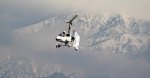
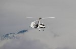
Aircraft: MICHAEL BURTON Calidus, registration: N50NE
Injuries: 2 Serious.

This is preliminary information, subject to change, and may contain errors. Any errors in this report will be corrected when the final report has been completed. NTSB investigators may not have traveled in support of this investigation and used data provided by various sources to prepare this aircraft accident report.
On May 20, 2016, about 1100 mountain daylight time, an experimental amateur-built Michael Burton (AutoGyro GmbH) Calidus, N50NE, collided with mountainous terrain near Fruitland, Utah. The gyrocopter was registered to the builder and operated by the pilot under the provisions of 14 Code of Federal Regulations (CFR) Part 91. The private pilot and passenger were seriously injured, and the gyrocopter sustained substantial damage. The cross-country personal flight departed Duchesne Municipal Airport, Duchesne, Utah, about 30 minutes prior, with a planned destination of Spanish Fork Airport-Springville-Woodhouse Field, Spanish Fork, Utah. Visual meteorological conditions prevailed, and no flight plan had been filed.

The pilot reported that they departed from Glenwood Springs Municipal Airport, Glenwood Springs, Colorado, earlier that morning and stopped at Duchesne for fuel. They then departed west towards Spanish Fork on a route over the Wasatch Mountain Range. As they approached the last ridge, about 200 ft above its peak, they encountered a strong downdraft and the gyrocopter descended 500 ft and into a box canyon. Unable to out climb the terrain, the pilot guided the gyrocopter over a river at the base of the canyon until he could see a landing spot on the shore. As he approached the site and initiated the landing flair, the right wheel struck a bolder and the gyrocopter rolled over, coming to rest in the river.

A witness, who was fishing in the river, called 911 after climbing to a peak where he was able to receive cell phone reception. Due to the remoteness of the site, the pilot and passenger were not recovered until later in the evening.


200 feet over peak - is that enough?
 
I personally have not flown over mountains in the west but just on the east which are smaller 6500 feet max. But regardless crossing a mountain range generally is advised to be done diagonally and my friends who do fly in Sierra Nevada etc. tell me 1500 to 2000 feet 2 to 5 miles before and till 2 to 5 miles after so 200 feet above the peak sound very low.
 
Stan you are a funny old goat.

Remember I'm not a pilot.

It's a very simple question.

Abid gave an insight answer that shares knowledge - you did not

As you may say - ""I believe you could have left your "comment" off your post Stan. It makes you look like a child"
 
Not to worry Steve, none of us pilots ever forget that you arent one.
 
It appears to me that 200 feet was not enough clearance to be clear of down drafts.

The wind there is is the higher I fly above ridgelines.

Most people I know that have mountain flying experience advise 2,000 feet clearance and not more than 20kts of wind.

I typically allow for 1,000 feet above ridgelines although it is not unusual for me to fly up valleys below the ridgelines or through a pass.

I was not flying that aircraft that day in that place so I don’t know what I would have done. I don’t know exactly why it didn’t work out.

Many times I have found downdrafts that I can’t out climb and more than once I have told Santa Barbara approach “unable” when they have asked me to maintain at or above a specific altitude near the San Marcos pass. I once found an updraft that took me to 8,000 feet over a 3,500 foot mountain pass at idle.

Given the area the pilot trained (Spanish Fork) I suspect he had more mountain flying knowledge than most of the gyroplane pilots on the Rotary Wing Forum even though he is a relatively low time pilot.

It was hard for me to imagine the effect of strong turbulence until I had experienced it. At first I thought it would be ok if I just had a little more power. I don’t feel that any more.

I am glad he survived the experience to become a better pilot.
 
Last edited:
It is altitude, horse power is considerable less at altitude,you think that they didnt want a

higher alt than a couple of hundred feet.That gyro is underpowered for that elevation

there is no way 4-5 thousand ft of clearance was going to happen,and as you know the

power that lee side rotors have are beyond description.


Best regards,
 
Seems they really needed to get to Spanish Forks and were willing to take some risk to get there. Michael certainly knows his mountain flying and there probably was a good reason he didn't have more clearance than 200 ft (lack of performance?). This is a great reminder that accidents can happen to the best of us.

Along that train of thought I remember what my old vetran instructor told me about aviation decision making: "If you, in hindsight, don't think that half of your decisions were too conservative, you are flying too aggressively."

Greetings, -- Chris.
 
Top